Minetrak
Modern mining methods demand accurate positioning and progress. MineTrak is a portable, simple and affordable application for Android® devices allowing opencast mining personnel to put themselves at the right place, at the right time.
Features
- Position tracking using GPS1
- Uses SA grid, Lat-Long co- ordinates or locally defined co-ordinates
- Upload faces or path features from survey data
- Record and tag paths and features
- Guided Navigation
- Local maps are automatically downloaded2
- Import/Export survey data from Microsoft Excel
- Set up tally systems for trip counts
- Grid block and mine plan overlays
- Proximity alarms
- Aerial photograph overlays
- Meta-data colorized overlays
- Runs on all Android device running ICS or higher (7” or larger screen recommended).
Overview
Modern mining methods demand accurate positioning and progress. MineTrak is a portable, simple and affordable application for Android® devices allowing opencast mining personnel to put themselves at the right place, at the right time.
Whether you’re an operator needing to collect material from the correct block, a supervisor updating pit faces, a geologist setting out prospecting boreholes, or the manager wishing to accurately track mining progress in between formal surveys, MineTrak is the solution.
MineTrak runs on any Android® device*, allowing you to keep tabs on mining progress from your smartphone, or a 10” tablet. It is the indispensable tool for keeping track of pit operations - without the need of a surveyor.
Navigate, record, or update information in the field, and then download the captured data into a Microsoft Excel spreadsheet for further processing.
Alternatively, upload survey data from Excel onto your device to overlay pit faces, geological features, control points, grid blocks, maps, aerial photographs or any other survey data.
Why MineTrak, and not just Google Maps?
All modern tablets and phones come with Google Maps these days. You might be asking, why not just use that for mine planning?
Make no mistake, Google Maps is a wonderful product. But as wonderful as Google Maps is for personal navigation and finding restaurants, it wasn’t designed for the kind of high accuracy applications that Mine Planning requires.
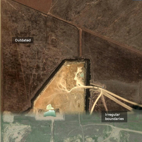
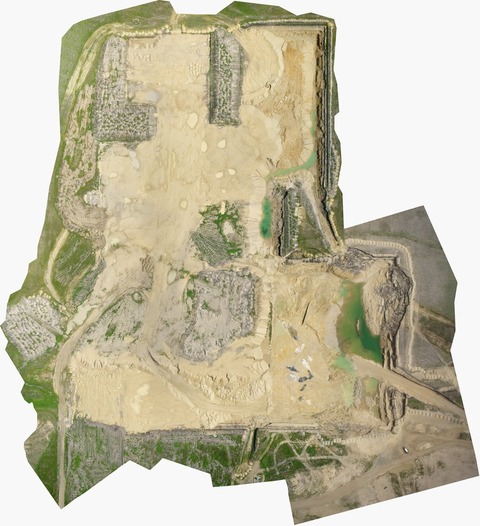
Consider the two screenshot sections below. The left hand image comes from Google Maps. The right-hand image is of the same area using aerial photography set up to be installed into MineTrak.
You’ll immediately notice a few things:
Obsolescence: Firstly, they don’t even look like they come from the same area. Well, that’s because you have no control over how often Google updates their satellite images. The image on the left is several months out of date and is effectively useless as a visual aid for Mine Planning purposes. In fact, one doesn’t even know when these images were actually taken. You have no control at all. After all, Google is interested in mapping the entire planet. They aren’t terribly interested in keeping your mine photos up to date. We are.
Consistency: The Google image is actually an amalgam of a set of photographs taken at different times. The image isn’t even internally consistent.
Clarity. Luckily, it was a clear day when the satellite images on the left were taken. Often, there are clouds obscuring the ground and that’s no good.