Control networks - Establishing control surveys for new projects and extending existing ones
Topographical surveys - Mass data capture of medium to high accuracy ground detail for DTM development and contouring. Click Here…See DTM Image
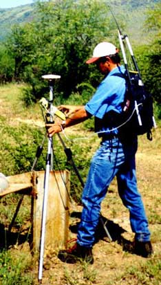
Surface Detail - Rapid gathering of surface detail utilising vehicle and back-pack mounted receivers, in real-time or in post-processing mode. Click Here…See RTK Backpack
Profiles and Sections - Site specific topographical data capture utilising realtime navigation.
Exploratory borehole sites - Planning,setting out and final capture.
Geophysical grids - Setting out of planned grids in a single pass in realtime.
Aerial photo control networks - Setting out and survey of aerial pre-marks or post photography photo identification.